How to draw USA map using Basemap in Python
 Faruque Ahamed Mollick
Feb 16, 2023
Faruque Ahamed Mollick
Feb 16, 2023
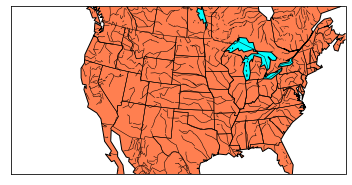
Learn how to use basemap to draw USA map in Python. We will add lake color too. The map output is also given.
Well, this project needs the following packages:
- Matplotlib
- Basemap
Make sure you have installed both of these packages before running the code.
The output will be like this:
Steps are easy:
First, create a new map.
Then, draw coastlines and country boundaries.
Now, draw states boundaries and rivers.
Now we are ready to fill the ocean and lakes using map.fillcontinents(color='coral',lake_color='aqua')
Finally, draw the map. Use plt.show().
Project Files
/
Loading...
| .. | ||
| This directory is empty. | ||
